An account of Nagpur state from 1790

This is an interesting account of Nagpur state from late eighteenth century. It is part of a small book titled Journal Of A Route To Nagpore by Daniel Robinson Leckie. I have taken some liberty to replace the long s typeset as f with regular s. For example, coft is cost. Some of the names are in archaic English but one can make sense of the them. For example Peshwa is Paishwah. This account shows the extent of the Rajah of Nagpore’s territories as well as some peculiarities of the region. Some of the places that are mentioned are the fortifications, palace, Jumma Talao, Sakkardarah etc. The account also has a short, somewhat incorrect, history of the house of the Bhoslas. Leckie says the Nagpur Bhoslas were descended from Shivaji’s house which clearly was not the case. Also there are remarks on the current affairs of the Nagpur state with the Peshwa in Pune and Chatrapati in Satara.

ACCOUNT OF NAGPORE,

&c. &c.

NAGPORE, situated in 79º 46′ east longitude from Greenwich, and 21º 49′ north latitude, is the present capital of Gondwauna1, a name little known to Europeans, perhaps owing to the remote situation of it from our settlements, and the Rauj2 of that name having been dismembered before we possessed any territory in India, at which time the comparatively confined state of the affairs of the Company did not lead to geographical inquiries.

I have taken no small degree of pains to ascertain the boundaries of Gondwauna; and though I will not pretend to say that the information I have procured is in every respect: exact, yet it may serve to give a general idea of the extent of the country.

It is not amiss to observe, that the people of this place are by no means communicative, and very circumspedt in giving information, particularly to Europeans, and it has cost me no small degree of trouble to collect what trifling information this account contains.

Gondwauna is bounded on the north-east; by an imaginary line, drawn from the town of Belhare to the city of Ruttunpoor; on the south-east by such another imaginary line, drawn from Ruttunpoor through the village of Soormul (situated about five coss to the north-east of Nurrah, which last is laid down in the map), to the junction of the Oordah and Beingunga rivers; on the south-wedt by the Oordah (Wadha) river; and pn the north-east by that chain of mountains which separates it from Malwa.

When Gondwauna was partly reduced by Aulumgwer, he obliged a great number of the natives together with the Rajah, to embrace the Mahomedan religion ; and the country remained for a series of years in this situation, the Rajah paying a fort of homage to the Moghul, as lord paramount : when, in the beginning of the present century, Ragojee Bhooshla, descended from the great Sevagi, reduced the greatest part of Gondwauna, to the south of the Nurbudda, with the province of Berar. The lenity with which he treated the Gonde Rajah deserves particular mention, as it shows a trait of humanity in the Merhattahs worthy of the highest pitch of civilization. He not only abstained from all forts of personal violence, but allotted three lachs of rupees annually for the Gonde Rajah’s maintenance, and the fort for him to live in, by no means as a confinement. Burhaun Shah, the son of the conquered Rajah, has still handsome allowances, and the fort to live in ; and the confidence which the late Moodajee placed in him was great: for what could be a greater mark of it in the East, than putting his family and women under his charge when he went upon any warlike expedition? which he constantly did.

Ragojee was the founder of Nagpore, which he surrounded with a rampart, it being only an insignificant village appertaining to the fort prior to his capture of it. It is situated oh a high plain, is richly cultivated, and produces fine wheat, and bounded by hills to the north- west and south. The Nag Nudde, a rivulet running to the southward, gives name to the town.

The houses are generally meanly built and covered with tiles, and the streets are narrow and filthy. The only good building is the palace, begun by the late Moodajee, and now finishing by his fon, the present Rajah ; it is built of a blue done dug out of a quarry in large blocks on the western skirts of the town. The present Rajah, however, has destroyed the grand effect which would have been produced by the stone alone, by intermixing brick-work in the building. There is a very large and deep3 tank near the west gate, called Jumma Tallow, three sides of which are handsomely built up with masonry ; and the Rajah has a foundery to the southward of the town, called Shukerderri, where he calls tolerably good brass guns. There, with some few gardens of the Rajah’s, neatly laid out in walks planted with cypress-trees, and interspersed with fountains, are the only places of note at Nagpore.

It should appear that Major Rennell (Memoir, second edition, 4to. page 12) is not perfectly clear with regard to the idea he has formed of the Merhattah state, that all the chiefs owe a fort of obedience to the Paishwah, resembling that of the German Princes to the Emperor. The account I heard from the Dewaun4 in the Durbar5 was,

But the fine extensive country which the Paishwah occupies, together with the advantage of playing the Sattarah puppet, will always give him influence with the other chiefs.

“That there is a person whom they call the representative of the Rauj, who is kept in the fort of Sattarah, and he is treated with all imaginable respect when he makes his appearance at Poonah, which is only upon particular occassions ; and when at Sattarah he is supplied with every luxury, and magnificently attended. On the demise of this image of government the handsome son of some poor man is chosen to supply his room. The Paishwah is prime minister to the Merhattah state; the Rajah of Nagpore, &c. commander in chief of the armies ; and they, as well as the rest of the chiefs, call themselves. servants of the Rauj; and none acknowledges the least immediate authority of the Paishwah, but they are all bound in cafes of necessity to render mutual assistance to each other, for the public good of the constitution.’’

The present Rajah, Rogojee Bhooshla, the grandson of the Conqueror (Ragojee the first was succeeded by his eldest son, Jannojee who was succeeded by his brother Sabage, who was slain in battle by Moodajee, the father of the. present Rajah. I have not the particulars their histories) does not seem to be either adapted to civil or military business ; he is generally dressed plainly in white, but wears costly diamonds and pearls; his behaviour is courteous to strangers. His great penchant is for elephants and mares. He has about 200 of the former, the finest; I ever beheld; and they are fed so sumptuously with sugar-cane, treacle, ghee, &c.. and not unfrequently fowl pallow, that they become almost mad with lust, breaking their chains and doing great mischief, which is considered by the Merhattahs as fine sport. The principal people about the Rajah are, his brother, Munnea Bapoo, a very quiet young man; Bhowaunny Caulloo, the Dewaun, a shrewd old fellow, and his nephew, Pondrang, the commander and paymaster of the army; Siree Dhur, the Monshee; and Mahadajee Leshkery, the Rajah’s confident, who is consulted on all occasions.

The Rajah does not keep up above 10,000 horse, the pay of which, as is the custom among all native princes, is irregularly distributed. He has two battalions of Sepoys, armed and clothed like ours ; and although they have been drilled by black officers, formerly belonging either to the Nabob of Lucknow, or our service, yet they go through their exercise very badly, and I do not think they will be able to make a stand against any body of native Sepoys disciplined by European officers.

I have heard that the total collections of the Rajah’s dominions, including Ruttunpore and Cuttae, only amount to seventy lacks of rupees per annum. I will not, however, pretend to affirm that this is exact though I do not think it can much exceed that sum; for the Rajah’s country, notwithstanding the great extent of it, does not contain a proportionable quantity of cultivated land to that which is waste and occupied by forests.

It is generally supposed that Nagpore is the capital of Berar. This is evidently a mistake. The inhabitants of Nagpore talk relatively of Berar as an adjoining province, as we do of Bahar to Bengal; and it has been shown that Nagpore is a city of late date. Elichpour is the capital of Berar, by the accounts I have received from the natives, who represent it as a very ancient city, and much larger than Nagpore.

A custom prevails in this town, which I cannot forbear taking notice of, because it serves to prove that long usage will give a plausibility to things seemingly the most preposterous. The bramins and best people at Nagpore have women attendants upon their families, whom they breed up from their childhood, and are called Butkies, or Slauls. They attend on their masters and mistresses during the day-time, and are permitted to go to any man they please in the night; some of them become very rich, and they are in general very handsome, fine women.

Nagpore,

August 20, 1790.

(Daniel Robinson Leckie)

Journal Of A Route To Nagpore

1The three ancient capitals of Gondwauna were Gurry Mudlah, Gurry *****, and Deogur.

2The dominion of a Raujah is called a Rauj, that of a King is denominated a kingdom.

3Pond

4Minister

5Court

When Kings Rode To Delhi…

Recently read a book titled When Kings Rode to Delhi by  Gabrielle Festing, which is available here. In the book there is a chapter on Sivaji called The Mountain Rat, title supposedly given by Aurangazeb to Sivaji. After the killing of Afzal Khan, this is what the author has to say:

 In the eyes of a Maratha, who believed himself Bhavani’s chosen warrior, such treachery was meritorious, and the slaughter of the envoy was an act of devotion.

Further the author describes various exploits and acts of Shivaji and in the end he says:

An attempt has been made to cast a glamour about him and his hordes, as patriots, deliverers of their country from foreign rule, devoted heroes who faced desperate odds. After a dispassionate survey no glamour remains. Sivaji was a typical Maratha of the best kind that is to say, he was as unlike the Rajputs from whom he claimed descent as the South African Boer from the good Lord James of Douglas. Never, unless they were driven to it, did the Marathas fight a pitched battle in open field ; the joy of fighting, which made the Rajput deck himself with the bridal coronet, the desperate valour which heaped the plain of Samugarh with yellow robes till it looked like a meadow of saffron, was incomprehensible to the wolves of the Deccan. They fought, not for a point of honour, or because they enjoyed fighting, but in a commercial. spirit, for the sake of what they could get; their word for “to conquer in battle” means simply “to spoil an enemy.” The Rajput was indolent, when not roused by pride or the thirst for battle; the Maratha was untiringly energetic as long as he had anything to gain, but would sacrifice nothing for pride or scruple.
This must be said for Sivaji, that while he lived his followers were forbidden to plunder mosques or women ; after his death his son pursued a different policy.

Vasai and Arnala

The Aim: To Do Vasai [Bassien] and Arnala Forts in one single trip.

The day finally came when the planned trip to Vasai fort had been finalised. This fort was long overdue. Maybe from last 4-5 years. Finally the party was decided. Finally the party was Mr. Jagdale and me. Sumit descended from Pune the night before and the rendezvous point was first decided at Dadar, but then changed to Bandra.
I woke up at 5:15 and woke up Sumit at 5:30 am. The scheduled meet was at 6:30 at Bandra Station. At about 5:50 I left HBC, since I had to get a ticket first, I had to miss two trains, and when I had the ticket, there was no train for next 15 minutes. Anyways reached Bandra at 6:45 via Vadala Road. Sumit wasn’t still there yet. So had to let go three more trains. When the last one was missed I guess we were the only two guys left on the platform. Anyways the next one was at 7:05 Virar fast. So we hopped up on that.

When the salt plains of Bhayendar could be seen we went to the gate. Early in the morning the coolness that you feel is really good. I wish the weather in Mumbai was the same throughout the day.

When we crossed the Bassien or Vasai creek a sense of freedom from the city of came. Anyways got down at Vasai Road at about 8:15. Then we checked into an Udipi hotel, had breakfast of the South Indian type.

We took an auto to Vasai Fort for Rs. 50 which we realised later was a larger payment than required. The drive through Vasai village gives you a feel of the country side. Along the road there was a market in which the locally produced [I guess] veggies were being sold. I had a desire to go and buy some, but considering the long day in front of us, decided against it. At the bus depot we took a left turn towards the fort. The fort became visible as we passed the Vasai police station. A part of the outer wall has been torn down to make the road, from where we currently enter the fort.

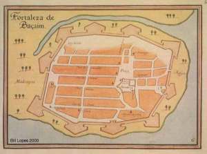
The fort has 10 bastions and is totally European in its architecture. The bastions are shaped like arrowheads, as opposed to rounded ones in India. The fort is strategically located to the North of Bassien creek. To the west there is marsh land. To east at present is the Vasai koliwada, to the south is the sea. To the north is the current city of Vasai . Out of the 10 bastions 9 were supposedly named as Cavallerio, Nossa Senhora dos Remedios, Reis Magos Santiago, Sam Gonçalo, Madre de Deos, and Sam Sebastião, Sam Sebastião.

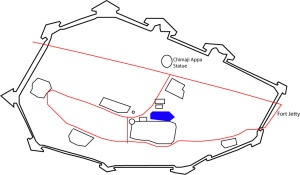
Below is a sketch map of the Vasai fort, drawn from the Wikimapia images.

Compare this with the old Portuguese maps, which I found here.


A brief history of fort is available at Wikipedia entry on the same. Also I found this site very informative with some original images of the fort. The Fort was won by Marathas under Chimaji Appa in 1739, with much casualties, before that it was the Portuguese capital of North Konkan. When in its full glory the Vasai fort must have been wonderful. Even the ruins of the fort are magnificent. You get a feeling of being transformed into their era when you are in them.

The auto took us to the fort jetty by a straight road which goes through the fort. The jetty is at the southern end of the fort. From the jetty there is a gate to enter the fort. This is one of the original entrances to the fort, and was known as Porta do Mor. The other gate is on the land side of the fort and appropriately called Porta da Terra [This one we could not see, as we did not know that it existed, when we went to the fort]. There are two baobab trees at the entrance. The baobab trees are native of Africa, were supposedly introduced by the Portuguese in the area. Actually Sunjoy Monga’s book Mumbai Nature Guide lists Vasai fort as one of the sites which harbors the baobab trees in the vicinity of Mumbai, about 6 specimens are listed, out of which we could see 5. We missed a really large one which is at the right to the sea side entrance of the fort. The species that we have here is Adansonia digitata [known as गोरख चिंच [gorakh chinch] locally]. For interesting information see www.baobab.com

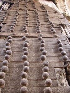
One interesting thing to note is that there still is a full wooden door, with all its ornamentation. I doubt it is the original one but it was a pleasant surprise nonetheless. As you enter the fort from this side there is a small temple on the left hand side, which was established by Chimaji Appa, when the fort was won.

The inner gate also has its wooden door intact.

We went up the stairs that are behind the small temple, which is one of the ten bastions of the fort [Though at that time we did not know that is was a bastion]. There were trees growing on the bastion floor!

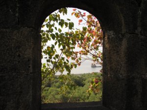
The windows of the bastion overlook the Bassien creek and give a nice view of the mangroves below and the fishing ships beyond.


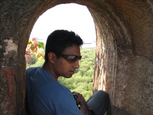
Sumit in one of th
e windows.

On the bastion a vine with yellow flowers was in full bloom. Ritesh the best taxonomer I know was not able to identify it [Id anybody?]. The plant was identified by Samir as Yellow Trumpet Creeper Macfadyena unguis-cati, also called Cat’s Claw. See the comment.
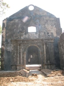
Then we went on to a cathedral. Deja-vu!! Simply because this location has been used in a lot of movies and also videos. Anyways the ceiling of one part of the cathedral is still intact. Though it has lost its lustre it must have been really magnificent.


This was our first major halt in the fort. The cathedral also has spiral staircase, which is very unique in construction. The steps and the axis are carved out in a single stone. See the picture and you will probably understand. Here again the bane of Indian archaeological sites viz. graffiti is abound. Some people are trying to make themselves known to the world at the cost of damaging and ruining our cultural heritage. Yuck!! I don’t know with what mentality people do this, are they trying to claim the place for themselves? Shame on them.

The tower below I guess is the highest point in what remains in the fort. There were parakeets on the overgrown trees on the top. Mr. Jagdale was full of adrenaline and he went along the walls to the otherside of the tower structure where this wonderful ceiling is present. He told that the ceiling part has been reinforced with concrete.

Here a lot of birds were seen, but could not ID[anyway I am not good at it] or take a shot at them. One bird of prey was in the sky above but did not get a good shot at it. [It is at moments like this I miss the telephoto lens 🙁 which I do not have].
We walked through dense cover of trees through a path, which took us to the citadel of the fort. The most prominent trees are mango [which was in full bloom], tamarind and dates.
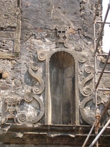
The citadel of the fort has an entrance which is small but very beautiful. There must have been a statue on the door; an empty space is a reminder of that. This is the initial fort of St. Sebastian which was extended into the larger fort.
The Portuguese coat-of-arms on the gate.

Here you can see two non-pillars; see the photo and you will understand.
There were fisher folks in the fort trying to process their webs with some sort of dye. Inside the citadel there is a small pond, which had some herons in it. We went along the wall to the end of it near a bastion. This bastion is circular though. When we went out of the citadel, we came up to the senate house of the fort. Next to the senate house is the lake which is almost at the center of the fort. Along side the lake are two temples, one of Vajreshwari and Nageshwar.
From here we took a right turn, where there were more ruins.


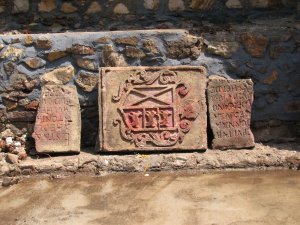
A stone plate with something in roman script [Can anyone translate this?].

From here we went inside towards the unknown, there were people sitting we asked them about more places to visit. They said that one of the old churches has been restored recently and that we should see it. They were the guardians of the mangoes of the fort. We went by the way told by the guardians and landed up at another place, which Wikimapia says is the Old Convent of St. Anthony.

Now this was an awesome place.


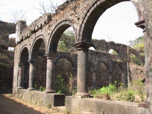
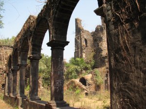
Arches are numerous as can be seen from the photos below.


One of the features of this place is the fact that the floor here has many graves. Some of them have coat of arms inscribed on them and some have names and the year of the burial all in roman script.

From the inside of the convent.


Then after this we went to the restored Augustinian Convent. Most of the restoration is of concrete :(.
Some initials which I would like to decipher. The date inscribed is 1626.

But the ceiling is all wood, and I guess has been done as it actually was.


From here on we hit back to the citadel where we came from. After pas
sing the Nageshwar temple we came to the ruins of the Dominican convent. This is another place undergoing restoration. Lots of re-construction going on. This was also a hospital.


Is not the statue missing?
The coat of arms here too…

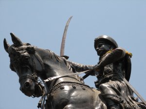
There was I guess a bell tower also here. From there we get to the main straight road which goes to the fort jetty. And across the road is the statue of the Chimaji Appa who captured the fort in 1739 from the Portuguese.

When the fort did not yield quickly Chimaji Appa said:

किल््ला हाती येत नाही, तर निदान माझे मस््तक तरी तोफेने उडवुन ते किल््लयात जाऊन पडेल असे करा.
Meaning: fort is not yet conquered, then put my head on the canon and at least make sure it lands inside the fort.
The geography of the Vasai fort is such that it allows attack option from the North only. On two sides the sea shore is there. And there are marsh lands on the other sides so blasting the walls with mines was not easy. But ultimately mines were laid and the Marathas got the entry through the Sebastian Bastion. Heavy casualties were inflicted on the Maratha side, about 12,000 as compared to about 800 on the Portuguese side. The Portuguese lost most of their generals and officers and the surrender was done by a Captain. The victory was described by Chimaji Appa thus:
या मागे युद््धे बहुत प््रापत झाली, परंतु मराठी फौजेस यासारखे युद््ध पडले नाही. सीमासीमाच केली. त््याचा िवस््तार िलहता विस््तार आहे. या जागा फत््ते होणे देवाची दया आहे.
Meaning [As I have understood, If you have understood it differently please let me know]: Before this Marathas have won many battles, but none like this one. This cannot be captured in words and this victory is beyond description. Conquest of this place is a grace of God.
The survivors were given a safe passage out of the fort and 8 days to take away movable properties. The fort and the buildings were ransacked and the bells in the churches were taken as mementos of victory. Two of the bells were installed at temples in Nashik and Sudhagad. You can see the pictures of the two here.
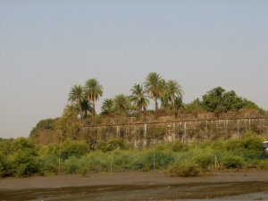
We went to the Sebastian bastion which lies to the backside of the Chimaji Appa statue. There again a magnificent baobab specimen is present.
The Sebastian bastion, from where Marathas gained entry.

The view of the bastions from the ground level, as they would have appeared to the attackers.

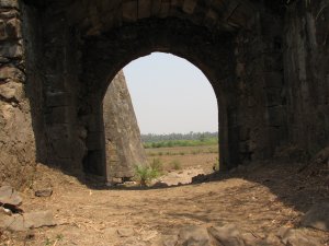
There is a small entrance here, which leads you out in the marshlands ahead. I took some shots of the bastions as they are seen from the ground level.
This was the end of our journey, we took an auto back to Vasai road station.
But this is one place I would surely like to visit in the Monsoons.
Now the journey continues to the next destination the Island fort of Arnala, but that will be another blog…